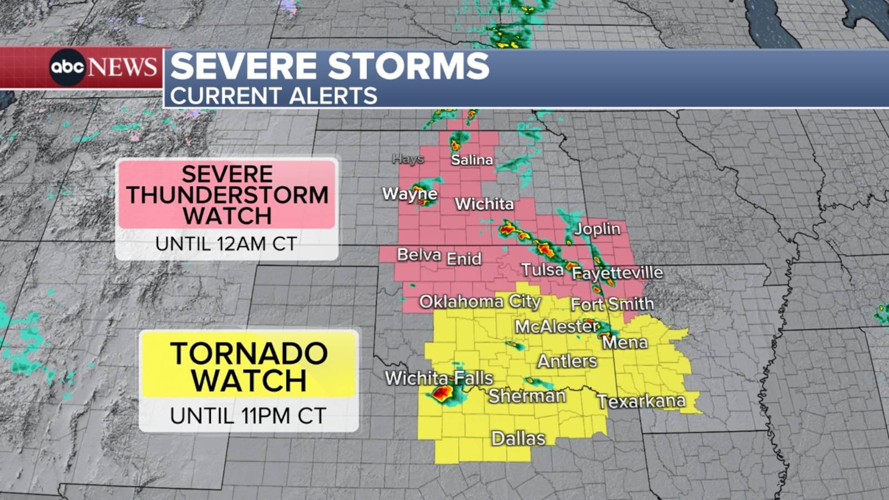
A severeweatherthreat has shifted back to the southern Plains, from Kansas down through Texas, with storms firing up Saturday evening and spurring watches for severe thunderstorm and possible tornadoes.
About 27 million people are at risk for some degree of these storms.
The tornado threat is greatest across southeastern Oklahoma into northern Texas, including Dallas, as well as western Arkansas.
Strong storms are also possible in northern Oklahoma, central Kansas and slivers of Arkansas and Missouri.
ABC News
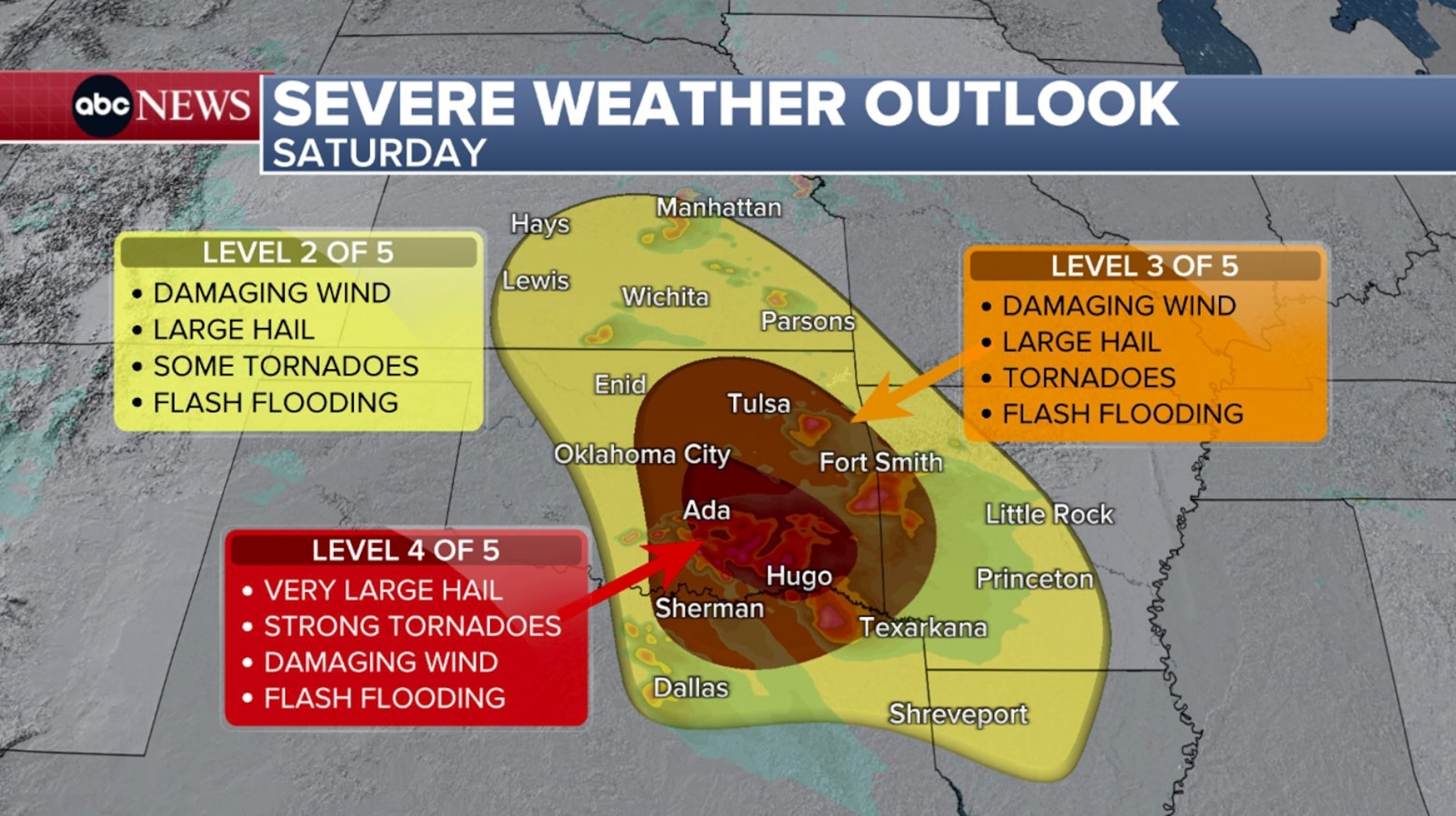
A level 4 of 5 «moderate risk» has been added for southeast Oklahoma and over the Red River into a sliver of Texas. This has the potential for very large hail (larger than baseballs), strong tornadoes, and damaging winds.
ABC News
A level 3 of 5 «enhanced risk» is up for much of eastern Oklahoma, down into northern Texas and eastward into Arkansas. In Oklahoma, this includes Oklahoma City, Tulsa, Broken Bow and Enid, as well as Fort Smith in Arkansas.
Damaging winds and very large hail are the primary threats with these storms, but few strong tornadoes are also possible.
Discrete supercells will be likely throughout the evening hours and will last into the overnight.
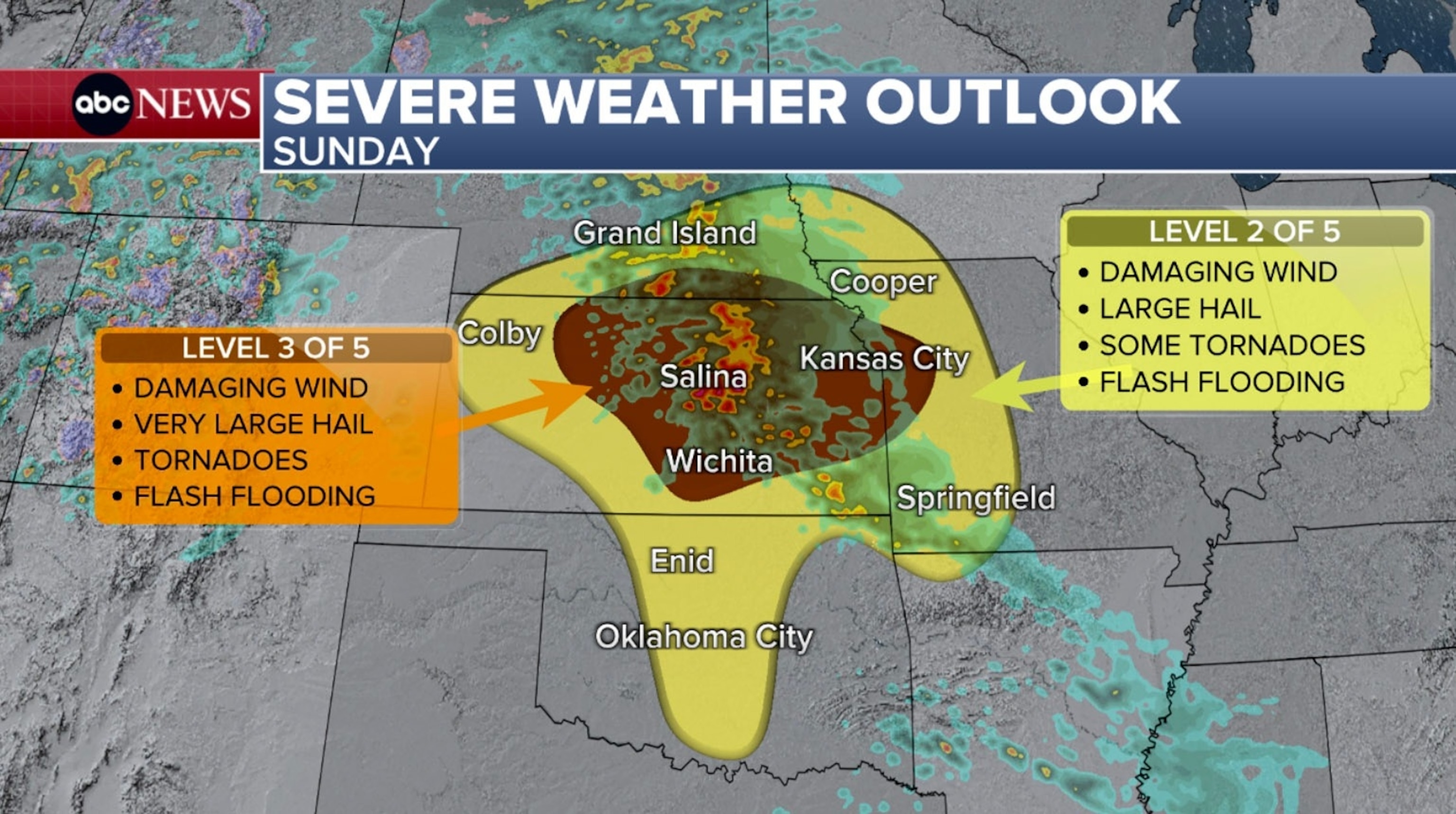
A new storm moves out of the Rockies for Sunday and will swing northeast across the Plains, bringing more severe weather.
ABC News
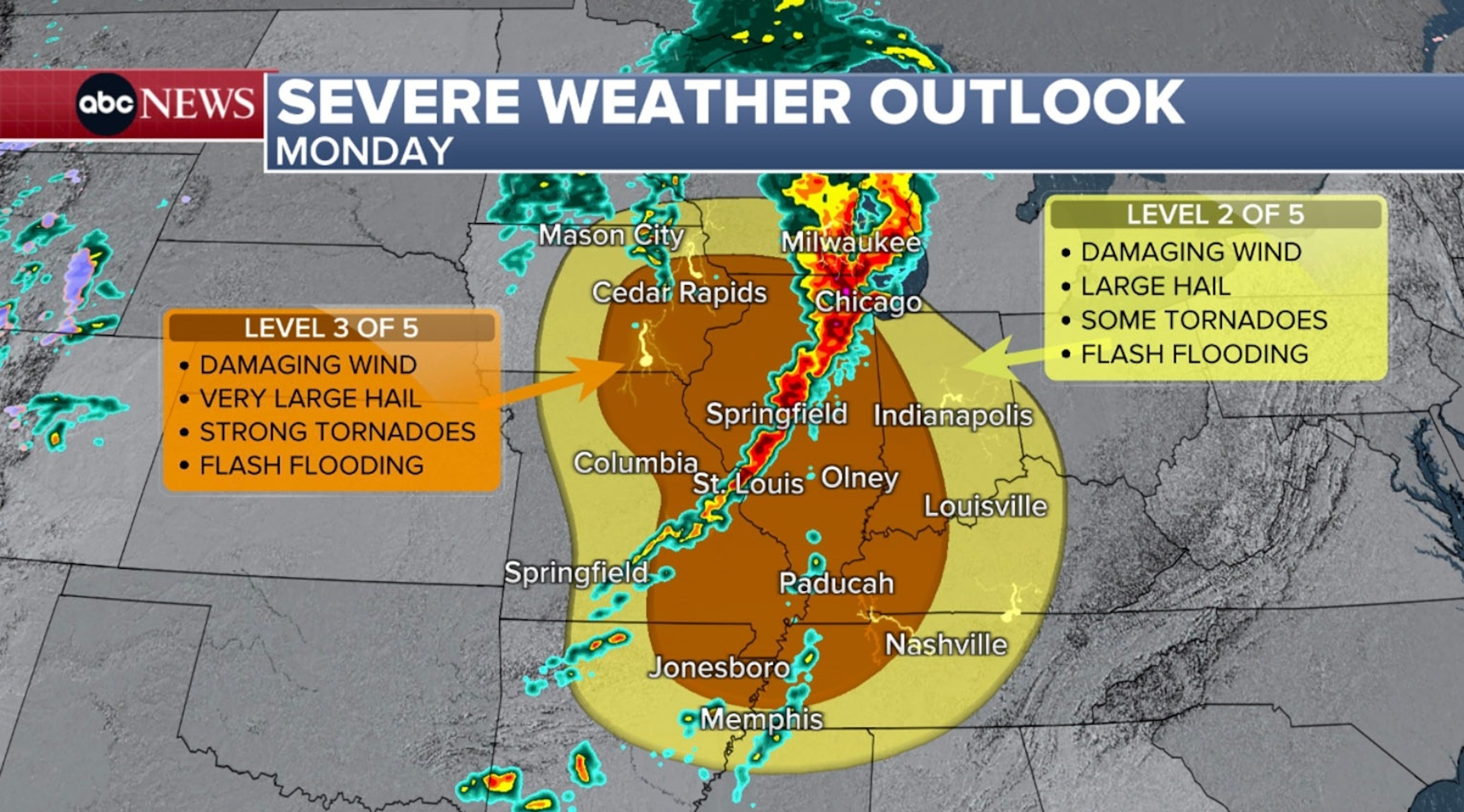
This threat will then push eastward and stretch into the Midwest on Monday.
For Sunday, a level 3 of 5 «enhanced risk» is up for much of Kansas as well as portions of western Missouri, including Wichita and Kansas City. Tornadoes, some being strong, as well as damaging winds and large hail are all possible with storms in this area.
A level 2 of 5 «slight risk» is also up for parts of northern Texas, northwest Arkansas, western Missouri, far southwest Iowa, southern Nebraska, most of Oklahoma and much of the remaining areas of Kansas.
For Monday, the severe weather threat spreads northeast and stretches across the Mississippi Valley up into the Midwest.
ABC News
The level 3 of 5 «enhanced risk» is up for cities like St. Louis; Cedar Rapids, Iowa; Jonesboro, Arkansas; Evansville, Indiana; Paducah, Kentucky; and Rockford, Illinois.
Popular Reads
A level 2 of 5 «slight risk» is up for cities like Memphis, Louisville, Kentucky; Chicago, South Bend, Indiana; Milwaukee, and Mason City, Iowa.
The threats are fairly similar for both days: widespread damaging wind gusts, large hail, a few strong tornadoes and spotty flash flooding.
On Tuesday, the severe weather threat shift to parts of the South. Places like Memphis, Little Rock, Arkansas; Tyler, Texas; Shreveport, Louisiana; and Jackson, Mississippi, will have to watch for potential severe weather later in the day.
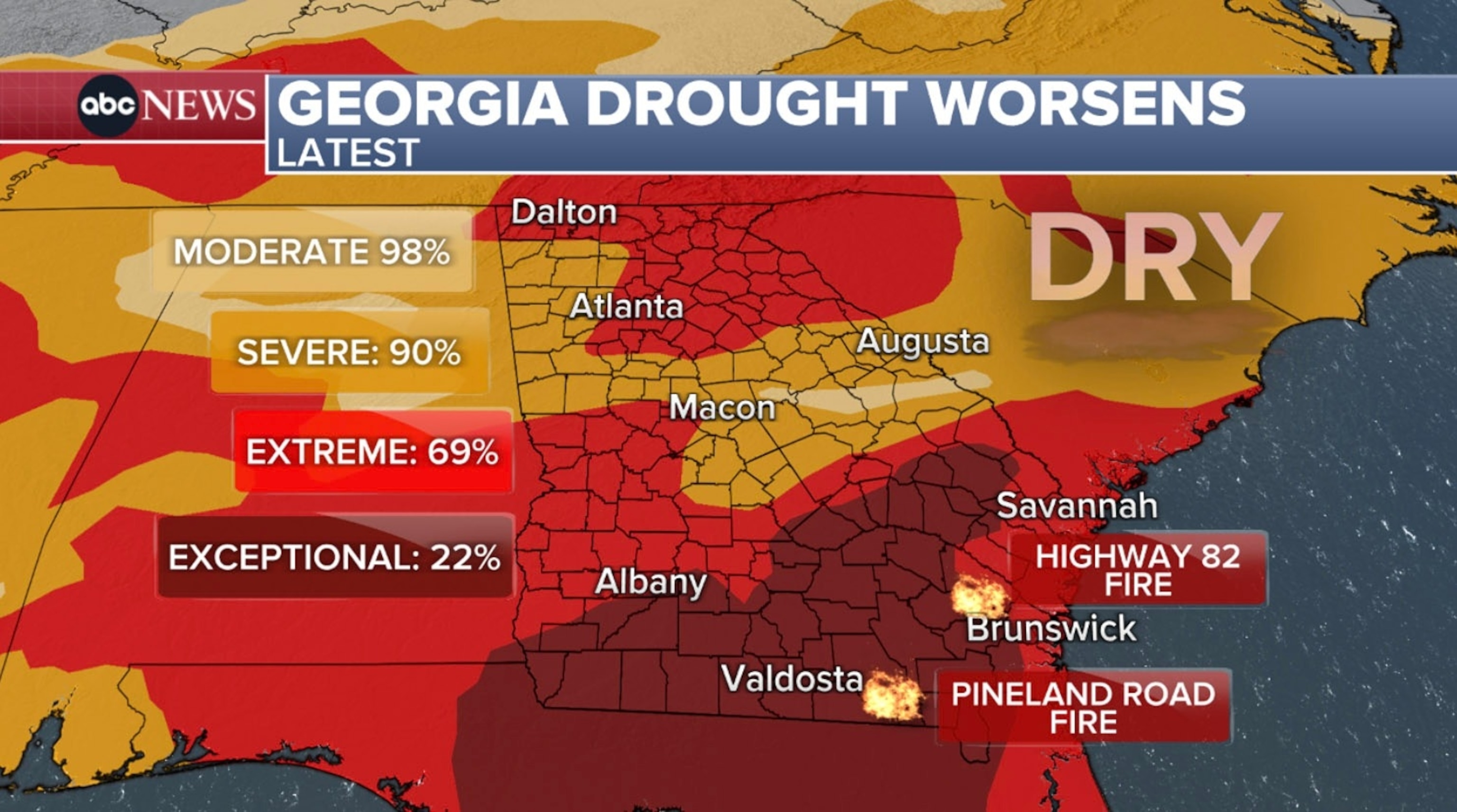
Wildfires rage amid severe drought
The drought in the Southeast continues to worsen, which is not helping reduce the threat for wildfires.
There are two actively burning in southeast Georgia — the Highway 82 fire in Brantley Countyand the Pineland Road fire in Clinch County.
ABC News
As of the latest update from fire officials, the Highway 82 fire is at 9,572 aces with only 10% contained.Evacuations continue, and a mandatory curfew remains in place in the county.
Both fires have burned over 40,000 acres and destroyed over 100 homes.
The driving force behind these fires is the immense drought that is plaguing the Southeast.
Some rounds of rain and possibly isolated thunderstorms will move into the region later Saturday and late Monday into Tuesday, with each round bringing around 0.5 to 1 inch of rain. This alone will not tame the wildfires, especially if it doesn’t fall directly where the fires are. In fact, any thunderstorms could cause lightning that may ignite additional wildfires in the dry region.
Some good news is that even if the rain does not materialize, increased humidity in the air will help the situation.
This problem isn’t going away soon. Georgia would need between 1 to 1.5 feet of rainfall to end the current drought.
